EN
°F
Change your measurements
Meters
Feet
°C
°F
km/h
mph
kts
am/pm
24-hour
Your settings have been updated
Change your language
Deutsch
Español
Italiano
Nederlands
中文
English
Français
日本語
Português
Today
7 days
Weather
Fishing
Water temp
United States
tide charts
Virginia
tide charts
Northampton County
tide charts
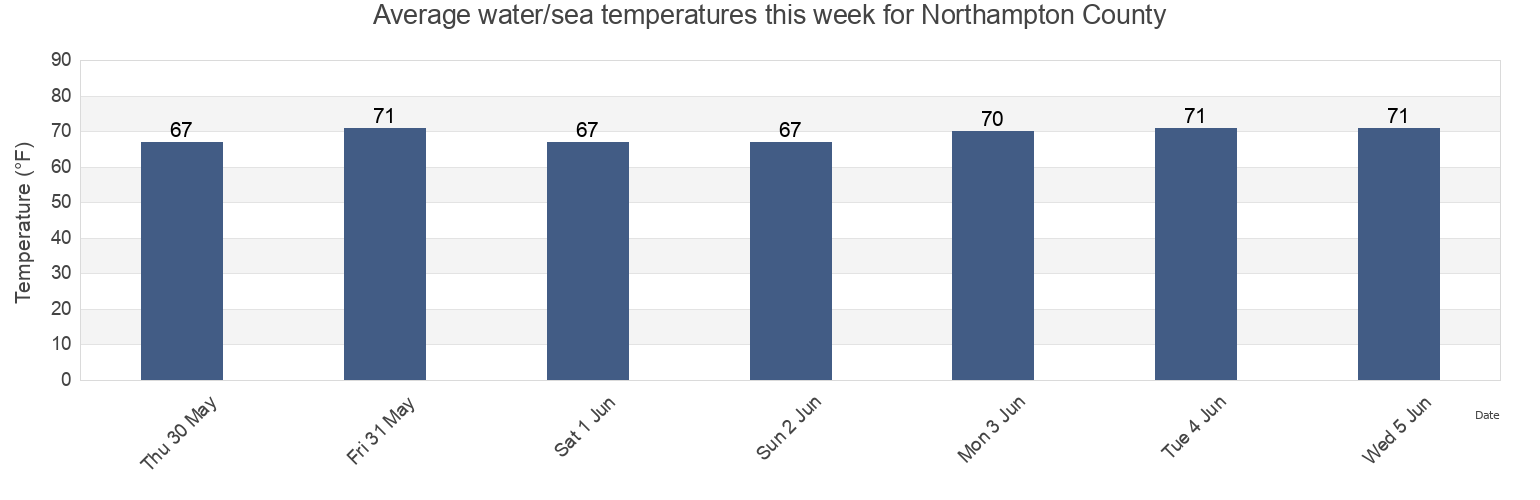
Northampton County water temperature
Northampton County water temperature for today, tomorrow and this week
More tide and marine information for Northampton County
Today's tides
Weekly tides
Weather
Fishing tides
Regions and cities in Northampton County, Virginia, United States
Butler Bluff 2.1 n.mi. WSW of
Fishermans I. 0.4 mile west of
Kiptopeke Beach
Cape Charles
Fishermans I. 1.1 miles northwest of
Old Plantation Flats Lt. 0.5 mi. W of
Cape Charles City 3.3 n.mi. west of
Fishermans I. 1.4 n.mi. WNW of
Old Plantation Light
Cape Charles Coast Guard Station
Fishermans Island
Oyster Harbor
Cape Charles Harbor
Fishermans Island 0.5 n.mi. SW of
Sand Shoal Inlet (coast Guard Station)
Cape Charles off Wise Point
Fishermans Island 1.4 miles WSW of
Ship Shoal Inlet
Show more locations
Cherrystone Inlet
Fishermans Island 1.7 n.mi. south of
Smith Beach
Chesapeake Channel (bridge tunnel)
Fishermans Island 2.45nm south of
Smith Island (coast Guard Station)
Chesapeake Channel (Buoy '15')
Fishermans Island 3.2 miles WSW of
Smith Island Shoal southeast of
Chesapeake Channel (Buoy 15)
Great Machipongo Inlet (inside)
Wolf Trap Light 5.8 miles east of
Church Neck Point 1.9 n.mi. W of
Hog Island
Wolf Trap Light 6.1 n.mi. ENE of
Eastville
Hungars Beach
York River Entrance Channel (SE end)
Exmore
Kiptopeke
York Spit Channel N of Buoy 26
Tide charts near Northampton County
Oyster Harbor
Eastville
Cherrystone Inlet
Cape Charles
Cape Charles Coast Guard Station
Cape Charles Harbor
Smith Beach
Hungars Beach
Sand Shoal Inlet (coast Guard Station)
Old Plantation Light