EN
°F
Change your measurements
Meters
Feet
°C
°F
km/h
mph
kts
am/pm
24-hour
Your settings have been updated
Change your language
Deutsch
Español
Italiano
Nederlands
中文
English
Français
日本語
Português
Today
7 days
Weather
Fishing
Water temp
United States
tide charts
Virginia
tide charts
Mathews County
tide charts
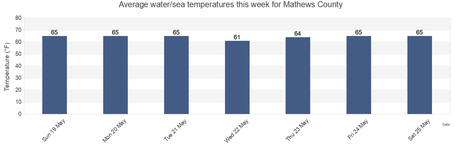
Mathews County water temperature
Mathews County water temperature for today, tomorrow and this week
More tide and marine information for Mathews County
Today's tides
Weekly tides
Weather
Fishing tides
Regions and cities in Mathews County, Virginia, United States
Bethel Beach
Little Creek (Railroad Terminal), Chesapeake Bay
Windmill Point Light
Bland Point Piankatank River
Mathews
Windmill Point Light 2.2 n.mi. ESE of
Cherry Point
Mobjack (East River)
Wolf Trap Light
Gwynn Island
Mobjack East River
Wolf Trap Light 0.5 mile west of
Gwynn Island 1.5 n.mi. east of
New Point Comfort 2.0 n.mi. WSW of
Wolf Trap Light 1.4 n.mi. NNE of
Gwynn Island 8.0 n.mi. east of
New Point Comfort 4.1 n.mi. ESE of
Wolf Trap Light 2.0 n.mi. NW of
Show more locations
Horn Harbor Marina
Stingray Point 1.2 n.mi. NE of
Wolf Trap Light 5.2 n.mi. ENE of
Jackson Creek (Deltaville)
Stingray Point 5.5 miles east of
Jackson Creek Deltaville
SW Branch, Severn River, Mobjack Bay
Tide charts near Mathews County
Bethel Beach
Mathews
Wolf Trap Light 2.0 n.mi. NW of
Horn Harbor Marina
Wolf Trap Light 0.5 mile west of
Wolf Trap Light
Wolf Trap Light 1.4 n.mi. NNE of
Mobjack East River
Mobjack (East River)
Gwynn Island 1.5 n.mi. east of