EN
°F
Change your measurements
Meters
Feet
°C
°F
km/h
mph
kts
am/pm
24-hour
Your settings have been updated
Change your language
Deutsch
Español
Italiano
Nederlands
中文
English
Français
日本語
Português
Today
7 days
Weather
Fishing
Water temp
United States
tide charts
Virginia
tide charts
City of Virginia Beach
tide charts
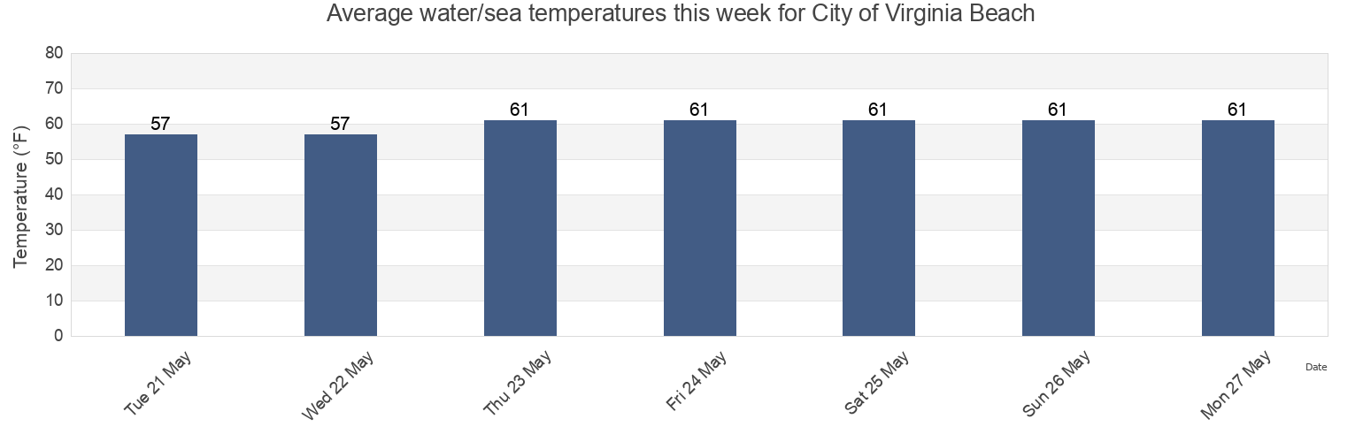
City of Virginia Beach water temperature
City of Virginia Beach water temperature for today, tomorrow and this week
More tide and marine information for City of Virginia Beach
Today's tides
Weekly tides
Weather
Fishing tides
Regions and cities in City of Virginia Beach, Virginia, United States
0.75nm west Thimble Shoal Channel
Cape Henry Light 4.6 miles north of
Lynnhaven Inlet Virginia Pilots Dock
42nd St VA Beach
Cape Henry Light 5.9 n.mi. north of
Lynnhaven Roads
Bayville
Chesapeake Bay Bridge Tunnel
Pleasure House Point
Broad Bay Canal
Chesapeake Bay Ent. 2.0 n.mi. N of Cape Henry Lt.
Pungo Ferry Marina
Brown Cove
Chesapeake Beach 1.5 miles north of
Rudee Heights (Lake Wesley)
Buchanan Creek Entrance
Damneck Naval Base
Rudee Heights Lake Wesley
Show more locations
Cape Henry
Lake Rudee (South End)
Rudee Inlet
Cape Henry Light 0.7 mile east of
Lake Rudee South End
Rudee Inlet Entrance
Cape Henry Light 1.4nm NE of
Linkhorn Bay
Rudee Inlet interior channel
Cape Henry Light 2.2 miles southeast of
Long Creek
Sandbridge
Cape Henry Light 2.35nm NNE of
Lynnhaven Inlet
Tail of the Horseshoe
Cape Henry Light 3.2 miles north of
Lynnhaven Inlet (Virginia Pilots Dock)
Virginia Beach
Cape Henry Light 3.4nm NNE of
Lynnhaven Inlet bridge
Tide charts near City of Virginia Beach
Damneck Naval Base
Sandbridge
Lake Rudee South End
Lake Rudee (South End)
Rudee Heights Lake Wesley
Rudee Heights (Lake Wesley)
Rudee Inlet interior channel
Rudee Inlet Entrance
Rudee Inlet
Virginia Beach