EN
°F
Change your measurements
Meters
Feet
°C
°F
km/h
mph
kts
am/pm
24-hour
Your settings have been updated
Change your language
Deutsch
Español
Italiano
Nederlands
中文
English
Français
日本語
Português
Today
7 days
Weather
Fishing
Water temp
United States
tide charts
Virginia
tide charts
City of Hampton
tide charts
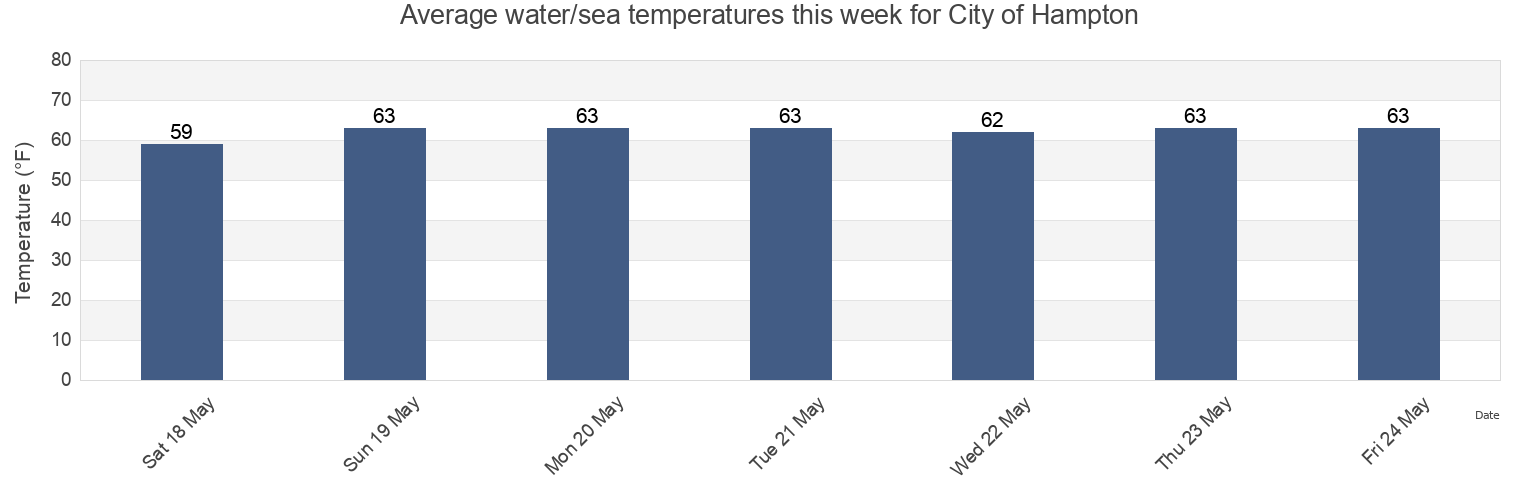
City of Hampton water temperature
City of Hampton water temperature for today, tomorrow and this week
More tide and marine information for City of Hampton
Today's tides
Weekly tides
Weather
Fishing tides
Regions and cities in City of Hampton, Virginia, United States
0.15nm WSW of Pier No.2
Hampton
Norfolk Harbor Reach (Buoy R 8)
0.2 mile south of
Hampton River
Old Point Comfort
0.55 n.mi. east of
Hampton River entrance
Pig Point
0.8 mile SW of shipbuilding plant
Hampton Roads
Pig Point 1.8 miles northeast of
0.9 mile southwest of
Hampton Roads (sewells Point)
Sewells Point
1.5 miles SW of shipbuilding plant
Hampton Roads entrance midchannel
Sewells Point (Naval Station Norfolk)
Show more locations
Buckroe Beach
James River Entrance
Sewells Point pierhead
Cape Henry Light 8.3 mi. NW of
Middle Ground 1 mile south of
Thimble Shoal Channel (west end)
Channel middle
Newport News
Thimble Shoal Channel 2.4 n.mi east of Ft. Monroe
Dandy Haven Marina
Newport News Channel west end
Willoughby Bay entrance
East Hampton
Norfolk Harbor Reach (Buoy R '8')
Willoughby Spit 0.8 mile northwest of
Tide charts near City of Hampton
East Hampton
Buckroe Beach
Hampton River entrance
Hampton
Dandy Haven Marina
Messick Point Back River
Hampton River
Messick Point (Back River)
Poquoson
Old Point Comfort