EN
°F
Change your measurements
Meters
Feet
°C
°F
km/h
mph
kts
am/pm
24-hour
Your settings have been updated
Change your language
Deutsch
Español
Italiano
Nederlands
中文
English
Français
日本語
Português
Today
7 days
Weather
Fishing
Water temp
United States
tide charts
Virginia
tide charts
Accomack County
tide charts
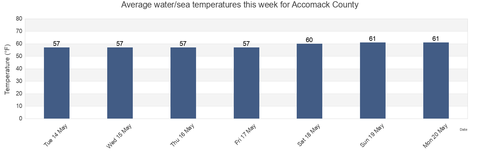
Accomack County water temperature
Accomack County water temperature for today, tomorrow and this week
More tide and marine information for Accomack County
Today's tides
Weekly tides
Weather
Fishing tides
Regions and cities in Accomack County, Virginia, United States
Accomac
Milby Point 5.3 n.mi. WNW of
Tangier Sound Light 5.8 n.mi. west of
Bluff Point 7.2 n.mi. east of
Muddy Creek Entrance
The Swash
Captains Cove
Nassawadox Point 1.9 n.mi. NW of
Upshur Neck (South End)
Chesconessex Creek (Schooner Bay)
Onancock
Upshur Neck South End
Chesconessex Creek Schooner Bay
Onancock (Onancock Creek)
Wachapreague
Chincoteague
Onancock Onancock Creek
Wachapreague Inlet (inside)
Show more locations
Folly Creek (Metompkin Inlet)
Pocomoke Sound Approach
Wachapreague Wachapreague Channel
Folly Creek Metompkin Inlet
Quinby Inlet entrance
Wallops Island
Gargathy Neck
Rappahannock Light
Watts Island
Gaskins Point (Occohannock Creek)
Revel Creek (Revel Island)
Watts Island 2.3 n.mi. east of
Gaskins Point Occohannock Creek
Revel Creek Revel Island
Watts Island 4 miles south of
Guard Shore
Stingray Point 12.5 miles east of
Wattsville
Harborton (Pungoteague Creek)
Tangier Island
Windmill Point Light 8.3 n.mi. ESE of
Harborton Pungoteague Creek
Tangier Sound Light 0.5 n.mi. east of
Metompkin Inlet
Tangier Sound Light 1.5 miles NE of
Tide charts near Accomack County
Chesconessex Creek Schooner Bay
Chesconessex Creek (Schooner Bay)
Onancock Onancock Creek
Onancock
Onancock (Onancock Creek)
Watts Island 2.3 n.mi. east of
Accomac
Guard Shore
Muddy Creek Entrance
Watts Island