EN
°F
Change your measurements
Meters
Feet
°C
°F
km/h
mph
kts
am/pm
24-hour
Your settings have been updated
Change your language
Deutsch
Español
Italiano
Nederlands
中文
English
Français
日本語
Português
Today
7 days
Weather
Fishing
Water temp
United States
tide charts
North Carolina
tide charts
Dare County
tide charts
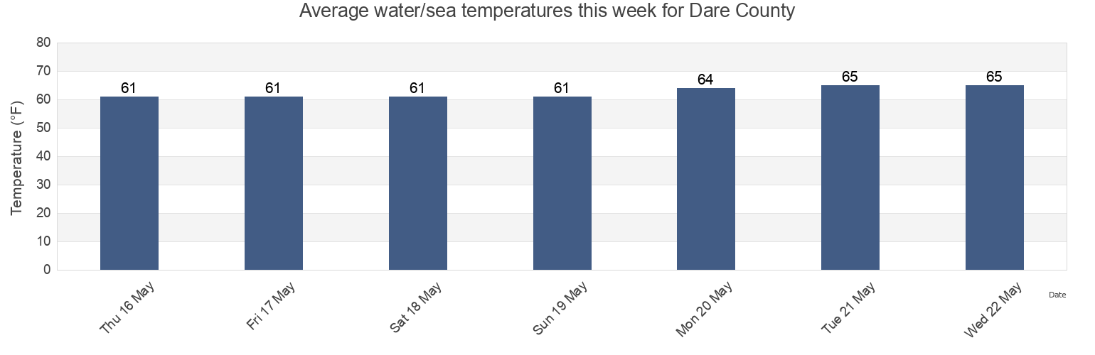
Dare County water temperature
Dare County water temperature for today, tomorrow and this week
More tide and marine information for Dare County
Today's tides
Weekly tides
Weather
Fishing tides
Regions and cities in Dare County, North Carolina, United States
Avon
Herbert C. Bonner Bridge WSW of
Oyster Creek
Avon Pier
Horseshoe Bay
Oyster Creek Croatan Sound
Bermuda Biological Station
Ireland Island
Pea Island
Bermuda Esso Pier
Jennettes Pier
Peters Ditch
Bodie Island-Pea Island
Jennettes Pier Nags Head (Ocean)
Roanoke Marshes Light
Bodie Island-Pea Island between
Jennetts Pier (ocean)
Roanoke Marshes Light Croatan Sound
Show more locations
Buxton
Kill Devil Hills
Roanoke Sound Channel
Cape Hatteras
Kitty Hawk
Rodanthe (Pamlico Sound)
Cape Hatteras (fishing pier)
Manns Harbor
Rodanthe Pamlico Sound
Cape Hatteras Fishing Pier
Manns Harbor Croatan Sound
Rodanthe Pier
Castle Island
Manteo
S Turns
Coast Guard Tower southwest of
Nags Head
Saint Georges
Coquina Beach
Old House Channel
Salvo
Dunkleys
Oregon Inlet
Sonesta
Esso Pier St Georges Island
Oregon Inlet (uscg Station)
Southern Shores
Ferry Reach
Oregon Inlet Bridge
The Reef
Ferry Reach (Biological Station)
Oregon Inlet Channel
Tuckers
Ferry Reach (Biological Station) Islands
Oregon Inlet Marina
Wanchese
Frisco
Outer Banks Hurricane
Waves
Great Sound
Outer Banks Pier
Tide charts near Dare County
Roanoke Marshes Light
Roanoke Marshes Light Croatan Sound
Oyster Creek
Oyster Creek Croatan Sound
Manns Harbor Croatan Sound
Manns Harbor
Wanchese
Manteo
Roanoke Sound Channel
Old House Channel