EN
°F
Change your measurements
Meters
Feet
°C
°F
km/h
mph
kts
am/pm
24-hour
Your settings have been updated
Change your language
Deutsch
Español
Italiano
Nederlands
中文
English
Français
日本語
Português
Today
7 days
Weather
Fishing
Water temp
United States
tide charts
New York
tide charts
New York County
tide charts
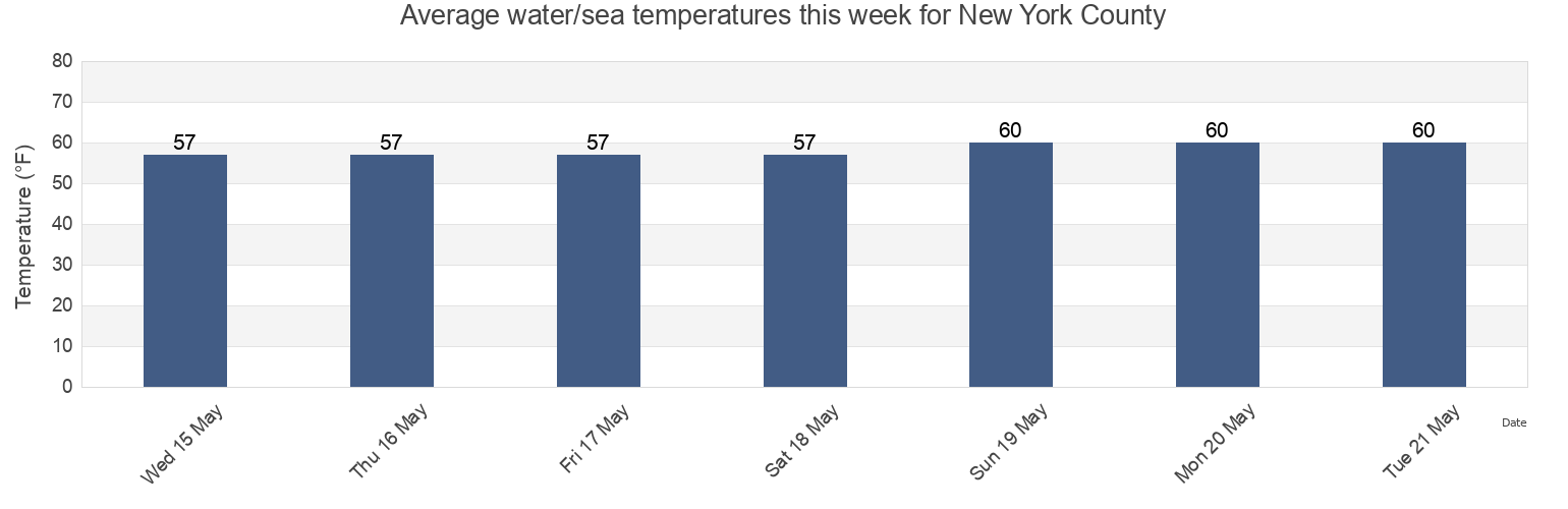
New York County water temperature
New York County water temperature for today, tomorrow and this week
More tide and marine information for New York County
Today's tides
Weekly tides
Weather
Fishing tides
Regions and cities in New York County, New York, United States
120th Street
Gueque
Mill Rock northeast of
130th Street
Hallets Cove
Mill Rock west of
37th Avenue, Long Island City, East River
Harlem River (Randalls Island)
New York City (East 41st Street)
48th Street
Harlem River Randalls Island
Off Winthrop Ave. Astoria
56th St
Hell Gate (East River)
Pier 67 off 19th Street
7th Avenue
Hell Gate Wards Island
Port Morris
Show more locations
81st Street
Hell Gate(off Mill Rock)
Port Morris (Stony Point)
Bananas Point
Horns Hook
Queensboro Bridge
Cromakill Creek N J Turnpike
Hunters Point (Newtown Creek)
Roosevelt Island, north end, East River
East 107th Street
Hunters Point Newtown Creek
South Brother Island NW of
East 110th Street
Lawrence Point
Turtles
East 19th Street
Liberty Island
Union Stock Yards
East 27th Street, Bellevue Hospital, East River
Macombs Dam Bridge
Wards Island
East 41st Street New York City
Madison Ave. Bridge
west of off 63rd Street
east of
Madison Avenue Bridge, Harlem River
west of off 67th Street
east of off 36th Avenue
Manhattan
west of off 75th Street
Edgewater
Manhattan 26th street
Willis Ave. Bridge 0.1 mile NW of
Grants Tomb
Manhattan off 31st Street
Wolcott Avenue
Tide charts near New York County
Turtles
7th Avenue
Manhattan
56th St
east of off 36th Avenue
west of off 67th Street
west of off 75th Street
west of off 63rd Street
Queensboro Bridge
east of