EN
°F
Change your measurements
Meters
Feet
°C
°F
km/h
mph
kts
am/pm
24-hour
Your settings have been updated
Change your language
Deutsch
Español
Italiano
Nederlands
中文
English
Français
日本語
Português
Today
7 days
Weather
Fishing
Water temp
United States
tide charts
New York
tide charts
Kings County
tide charts
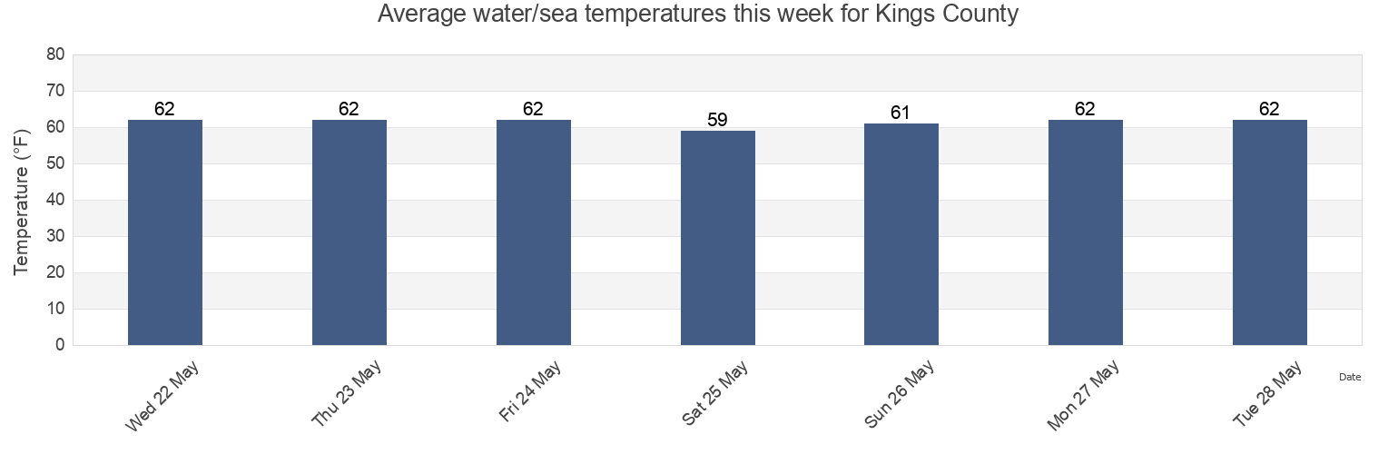
Kings County water temperature
Kings County water temperature for today, tomorrow and this week
More tide and marine information for Kings County
Today's tides
Weekly tides
Weather
Fishing tides
Regions and cities in Kings County, New York, United States
13th Street
Canarsie (midchannel off pier)
Norton Point
15th Street
Coney Island
Norton Point (Gravesend Bay)
17th Ave
Coney Island Brooklyn
Norton Point Gravesend Bay
40th Street
Dead Horse Bay
Plum Beach Brooklyn
64th Place
East New York
Plumb Beach Channel
Barren Island (Rockaway Inlet)
English Kills entrance
Red Hook Channel
Show more locations
Barren Island east of
Fort Tilden Queens
Rockaway Beach
Barren Island Rockaway Inlet
Governors Island
Rockaway Beach Queens
Bay Ridge Channel
Gowanus Bay
Rockaway Inlet entrance
Beach Channel (bridge)
Grassy Bay (bridge)
Rockaway Inlet Jetty 1 mile SW of
Bee Hives
Guacuco
Rockaway Point
Bensonhurst
Jacob Riis Park Queens
Sandbox
Brighton Beach Brooklyn
Manhattan Beach Brooklyn
Sheepshead Bay
Brooklyn
Manhattan Bridge East of
Wallabout Bay
Brooklyn Bridge
Mill Basin
Wallabout Bay Brooklyn Navy Yard
Brooklyn Bridge 0.1 mile southwest of
North 3rd Street
Williamsburg Bridge
Buttermilk Channel
North Channel Bridge (Grassy Bay)
Williamsburg Bridge 0.3 mile north of
Canarsie
North Channel Bridge Grassy Bay
Tide charts near Kings County
Brooklyn
40th Street
Mill Basin
17th Ave
Plum Beach Brooklyn
15th Street
13th Street
Bensonhurst
Canarsie (midchannel off pier)
Canarsie