EN
°F
Change your measurements
Meters
Feet
°C
°F
km/h
mph
kts
am/pm
24-hour
Your settings have been updated
Change your language
Deutsch
Español
Italiano
Nederlands
中文
English
Français
日本語
Português
Today
7 days
Weather
Fishing
Water temp
United States
tide charts
Massachusetts
tide charts
Suffolk County
tide charts
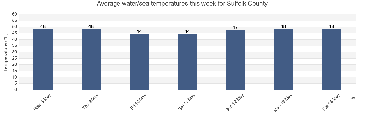
Suffolk County water temperature
Suffolk County water temperature for today, tomorrow and this week
More tide and marine information for Suffolk County
Today's tides
Weekly tides
Weather
Fishing tides
Regions and cities in Suffolk County, Massachusetts, United States
Amelia Earhart Dam (Mystic River)
Garths Reef
Peddocks Island west of
Amelia Earhart Dam Mystic River
Georges Island 0.3 n.mi. SSE of
Philip Head Town River Bay
Bass Point 1.2 n.mi. southeast of
Georges Island 0.4 n.mi. east of
Phillips Beach
Belle Isle Inlet entrance
Georges Island 0.4 n.mi. SSE of
Pig Rock north of
Black Rock Beach
Georges Island 0.4nm southeast of
Pig Rock northwest of
Black Rock Channel
Georges Island 0.5 n.mi. ESE of
Pleasure Bay Old Harbor Reservation
Show more locations
Boston
Georges Island north of
Point Allerton 0.4 n.mi. northwest of
Boston Channel Light No.5
Georges Island northeast of
Point Allerton 0.65 n.mi. NNW of
Boston Harbor (Deer Island Light)
Germantown Point
Point of Pines 0.1 n.mi. northeast of
Boston Light
Grape Island
Point of Pines 0.5 n.mi. south of
Boston Light 0.2 n.mi. south of
Grape Island and Lower Neck between
Rainsford I. and Windmill Pt. between
Bumkin Island 0.1 n.mi. west of
Gull Point 0.4 n.mi. ESE of
Rainsford Island 0.2 n.mi. NE of
Bumkin Island 0.4 n.mi. west of
Harbor Islands
Rainsford Island 0.4 n.mi. SE of
Calf Island 0.4 n.mi. west of
Hull
Revere
Carson Beach
Hull Gut
Revere Beach
Carson Beach Old Harbor Reservation
Hypocrite Channel
Sailing Club
Castle Island
Jacknife Ledge
Sand Point Black Marsh Channel
Charles River Dam
Jamaica Plain
Sandy Beach
Charlestown (Charles River Entrance)
Kings Beach
Sandy Cove
Charlestown Bridge
Little Brewster Island 1.5 n.mi. E of
Savin Hill Beach Dorchester Shores Reservation
Charlestown Charles River Entrance
Little Calf Island 0.4 n.mi. NW of
Scituate
Charlestown Pier 1
Little Nahant Cupola 0.6 n.mi. west of
Scituate Scituate Harbor
Chelsea
Long I. and Rainsford I. between
Sheep Island 0.3 n.mi. west of
Chelsea River below bascule bridge
Long Island Head 0.9 n.mi. NW of
Smith Beach
Chelsea River west of bascule bridge
Lovell Island 0.1 n.mi. south of
Snake Island southwest of
Chelsea St Bridge Chelsea River
Lovell Island 0.4 n.mi. north of
South Boston
Chelsea St. Bridge
Lovell Island 1.3nm north of
South Boston Pier 4 0.2 n.mi. NNE of
City Point 0.8 n.mi. SSE of
Lovell Island Narrows
South Channel Aldridge Ledge
City Point Beach Old Harbor Reservation
Lovell Island west of
Spectacle I. and Long I. between
Cohasset Harbor (White Head)
Lynn
Spectacle I. and Thompson I. between
Commissioners Ledge
Lynn Harbor
Spectacle Island 0.2 n.mi. south of
Constitution Beach Belle Isle Marsh Reservation
Lynn Lynn Harbor
Spectacle Island 0.4nm north of
Crow Point (Hingham Harbor Entrance)
M Street Beach Old Harbor Reservation
Squantum Point 0.4 n.mi. NNE of
Crow Point 0.2 n.mi. north of
Malibu Beach Dorchester Shores Reservation
Squantum Point 0.8 n.mi. northeast of
Crow Point Hingham Harbor Entrance
Marblehead
Stellwagen Basin 13.8nm SE of Eastern Pt. Light
Crystal Cove
Moon Head
Stellwagen Basin east end
Deer Island (South End)
Moon Head 0.4 n.mi. east of
Stodders Neck Weymouth Back River
Deer Island 0.7 nm ESE of
Moon Head 0.9 n.mi. southeast of
Strawberry Hill
Deer Island Flats
Mystic River Bridge 0.1 n.mi. west of
Sunken Ledge 0.2 n.mi. northwest of
Deer Island Light 0.3 n.mi. SSE of
Mystic River Bridge northwest of
Ted William Tunnel
Deer Island Light 0.4 n.mi. east of
Nahant
The Graves 0.3 n.mi. SSE of
Deer Island Light 0.4 n.mi. NW of
Nahant 0.4 n.mi. east of East Point
The Piglets 0.4 n.mi. northest of
Deer Island Light 0.4 n.mi. SSE of
Nahant 1 n.mi. SE of East Point
Thieves Ledge
Deer Island Light 0.7 n.mi. ESE of
Nahant 1.8 n.mi. NE of East Point
Thompson Island 0.7 n.mi. NNE of
Deer Island Light 0.8 n.mi. ESE of
Nahant Beach Lynn Shores Reservation
Weir River entrance
Deer Island Light 1.0 n.mi. WSW of
Nantasket Beach (Weir River)
West Head 0.2 n.mi. southwest of
Deer Island southwest of
Nantasket Beach Nantasket Reservation
West Head Long I. 0.4 n.mi. south of
Dorchester Bay Basin
Nantasket Beach Weir River
West Head Peddocks I. 0.1 n.mi. W of
Dover St. Bridge
Neponset (Neponset River)
Weymouth Back River Bridge
East Boston Pier 10 southeast of
Neponset Neponset River
Weymouth Fore River
Eismans Beach
Nixes Mate
Weymouth Fore River Bridge
Finn's Ledge Bell
Northeast Grave
Weymouth Harbor Entrance
Finns Ledge Bell 0.2 n.mi. west of
Nubble Channel
Windmill Point 0.7 n.mi. SSE of
Fishermans Beach
Nut Island
Winthrop
Fort Independence 0.1nm north of
Nut Island 0.2 n.mi. NNE of
Winthrop Beach
Fort Independence 0.3 n.mi. east of
Nut Island 0.4 n.mi. NNE of
Winthrop Beach Belle Isle Marsh Reservation
Gallops Island 0.1 n.mi. southeast of
Nut Island Quincy Bay
Winthrop Head 1.1 n.mi. east of
Gallops Island 0.2 n.mi. SSE of
Pea Island 0.4 n.mi. southeast of
Wollaston Beach Quincy Shore Reservation
Gallops Island 0.5 n.mi. southwest of
Peddocks Island 0.2 n.mi. north of
Yirrell Beach Belle Isle Marsh Reservation
Gallops Island The Narrows
Peddocks Island 0.3 n.mi. northwest of
Tide charts near Suffolk County
Boston
Dover St. Bridge
Charlestown Bridge
Charles River Dam
Charlestown (Charles River Entrance)
Charlestown Charles River Entrance
South Boston
East Boston Pier 10 southeast of
South Boston Pier 4 0.2 n.mi. NNE of
Ted William Tunnel