EN
°F
Change your measurements
Meters
Feet
°C
°F
km/h
mph
kts
am/pm
24-hour
Your settings have been updated
Change your language
Deutsch
Español
Italiano
Nederlands
中文
English
Français
日本語
Português
Today
7 days
Weather
Fishing
Water temp
United States
tide charts
Massachusetts
tide charts
Nantucket County
tide charts
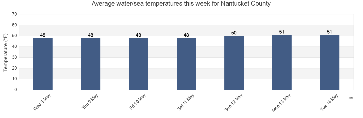
Nantucket County water temperature
Nantucket County water temperature for today, tomorrow and this week
More tide and marine information for Nantucket County
Today's tides
Weekly tides
Weather
Fishing tides
Regions and cities in Nantucket County, Massachusetts, United States
Brant Point
Halfmoon Shoal 3.5 miles east of
Nantucket Island
Childrens Beach
Handkerchief Lighted Whistle Buoy 'H'
Nobadeer Beach
Cisco Beach
Handkerchief Lighted Whistle Buoy H
Old Man Shoal Nantucket Shoals
Cross Rip Channel
Jetties Beach
Pocomo Head
Davis Bank
Long Shoal-Norton Shoal
Pollock Rip Channel (Butler Hole)
Dionis Beach
Long Shoal-Norton Shoal between
Pollock Rip Channel east end
Show more locations
Eel Point
Madaket Beach
Polpis Harbor
Eel Pt. Nantucket I. 2.5 miles NE of
Madaket Harbor
Siasconset Beach
Francis Street
Miacomet Pond 3.0 miles SSE of
Smith Point
Fundy (offshore 23)
Miacomet Rip
South Shore
Fundy (offshore 4)
Muskeget I. channel 1 mile northeast of
Surfside Beach
Georges Shoal Texas Tower
Muskeget Island (North Side)
Tom Nevers Head
Great Point
Muskeget Island North Side
Tuckernuck Island 4.2 miles SSW of
Great Point 0.5 mile west of
Nantucket
Tuckernuck Shoal off east end
Great Point 3 miles west of
Nantucket Harbor
Wauwinet (outer shore)
Halfmoon Shoal 1.9 miles northeast of
Nantucket Harbor entrance channel
Tide charts near Nantucket County
Nantucket Island
Polpis Harbor
Tom Nevers Head
Nobadeer Beach
Nantucket Harbor
Pocomo Head
Siasconset Beach
Old Man Shoal Nantucket Shoals
Francis Street
Childrens Beach