EN
°F
Change your measurements
Meters
Feet
°C
°F
km/h
mph
kts
am/pm
24-hour
Your settings have been updated
Change your language
Deutsch
Español
Italiano
Nederlands
中文
English
Français
日本語
Português
Today
7 days
Weather
Fishing
Water temp
United States
tide charts
Maryland
tide charts
Dorchester County
tide charts
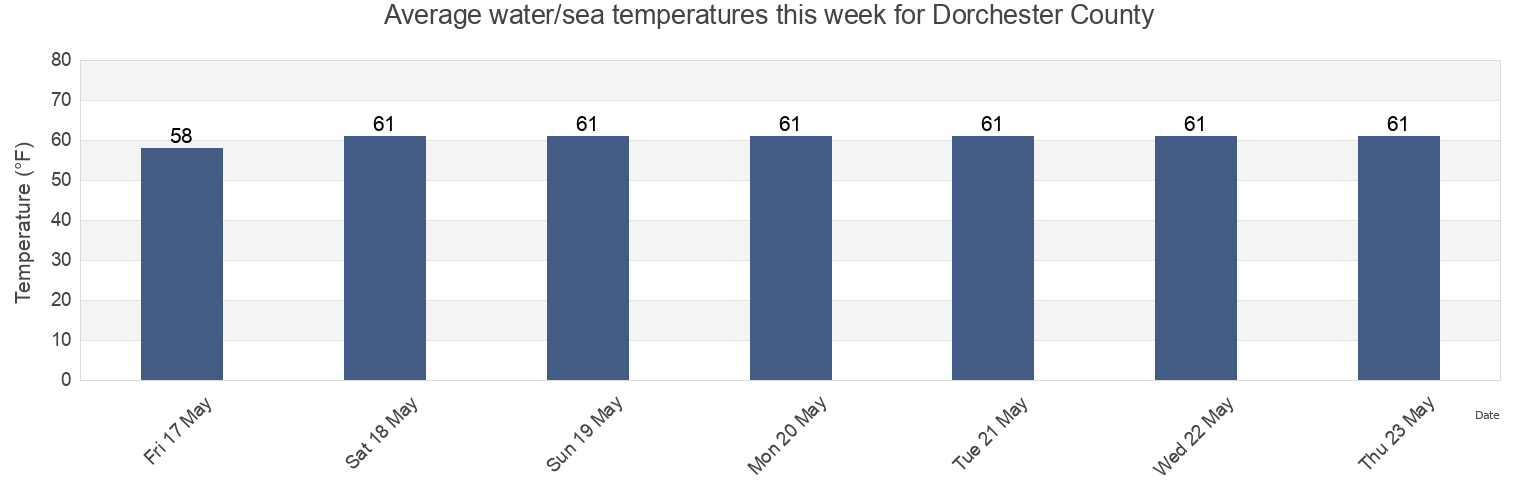
Dorchester County water temperature
Dorchester County water temperature for today, tomorrow and this week
More tide and marine information for Dorchester County
Today's tides
Weekly tides
Weather
Fishing tides
Regions and cities in Dorchester County, Maryland, United States
Barren Island
Cove Point (1.1 mi. NE of)
Madison Bay
Beaverdam Creek
Cove Point 1.1 n.mi. east of
Mccready's Creek
Blackwater Point
Cove Point 2.7 n.mi. east of
Mccreadys Creek
Cambridge
Cove Point 3.9 n.mi. east of
Middle Hooper Island
Cambridge hwy. bridge W. of Swing Span
Crab Cove
Piney Point
Cedar Point 1.1 miles ENE of
Elliott Island
Ragged Point 1.5 miles east of
Show more locations
Cedar Point 2.9 n.mi. ENE of
Fishing Point, Fishing Bay, Chesapeake Bay
Smithville Road Bridge Beaverdam Creek
Cedar Point 4.7 n.mi. east of
Honga River Entrance at Buoy 1A
Taylors Island (Slaughter Creek)
Cherry Island (Beckwiths Creek)
Hooper Strait (west) at buoy 2
Taylors Island Slaughter Creek
Cherry Island Beckwiths Creek
Hooper Strait Light
Woolford (Church Creek)
Choptank River Light, Choptank River
Hudson Creek
Woolford Church Creek
Tide charts near Dorchester County
Hudson Creek
Blackwater Point
Woolford (Church Creek)
Woolford Church Creek
Smithville Road Bridge Beaverdam Creek
Beaverdam Creek
Elliott Island
Mccready's Creek
Mccreadys Creek
Cambridge