San Juan County tide charts for today, tomorrow and this week

San Juan County, Washington, United States tide chart

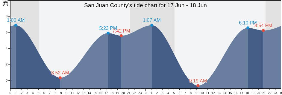
Wednesday 15 May 2024, 9:03PM PDT (GMT -0700). The tide is currently rising in San Juan County. As you can see on the tide chart, the highest tide of 7.87ft was at 12:57am and the lowest tide of 0.98ft was at 5:02pm. Click here to see San Juan County tide chart for the week.

Next high tide

Next high tide is at
1:34am

Next low tide

Next low tide is at
9:15am

Tide times for San Juan County

Tide table for San Juan County this week
Day Tide times for San Juan County Sunrise and sunset
1st Tide 2nd Tide 3rd Tide 4th Tide
Wed 1512:57am
7.87 ft
5:02pm
0.98 ft
5:31am 8:47pm
Thu 161:34am
7.55 ft
9:15am
3.94 ft
11:22am
4.27 ft
5:58pm
1.64 ft
5:30am 8:48pm
Fri 172:02am
7.55 ft
9:16am
3.28 ft
1:49pm
3.94 ft
6:54pm
2.62 ft
5:28am 8:50pm
Sat 182:23am
7.22 ft
9:28am
2.3 ft
3:34pm
4.59 ft
7:50pm
3.28 ft
5:27am 8:51pm
Sun 192:38am
6.89 ft
9:45am
1.31 ft
4:49pm
5.25 ft
8:43pm
4.27 ft
5:26am 8:52pm
Mon 202:48am
6.89 ft
10:04am
0.33 ft
5:48pm
5.91 ft
9:36pm
4.92 ft
5:25am 8:53pm
Tue 212:56am
6.56 ft
10:27am
-0.66 ft
6:36pm
6.56 ft
10:27pm
5.58 ft
5:24am 8:55pm

Current weather in San Juan County

Mist

Weather

Mist
Cloud cover 100%
Temperature

Temperature

48°F
Min 47°F/Max 57°F
Wind

Wind

7 mph
Wind gust 12 mph
Humidity

Humidity

96%
Dew point 47°F

Click here to see San Juan County weather for the week.

Today's weather in San Juan County

The sun rose at 5:31am and the sun went down at 8:47pm. Today there was 15 hours and 16 minutes of sun and the average temperature is 53°F. At the moment water temperature is 46°F and the average water temperature is 46°F.

Weather forecast for San Juan County today
0 h 3 h 6 h 9 h 12 h 15 h 18 h 21 h 24 h
Partly cloudyPartly cloudyPartly cloudyPartly cloudyPartly cloudyPatchy rain nearbyPatchy rain nearbyMistPatchy rain nearby
48°F56°F52°F56°F57°F55°F52°F48°F48°F

Click here to see San Juan County weather for the week.

More tide and marine information for San Juan County

Regions and cities in San Juan County, Washington, United States
Active Pass Galiano IslandGuemes Channel west entranceRosario Strait
Alden Point Patos Island 2 miles S ofHale Passage 0.5 mile SE of Lummi PointSaanichton Bay
Aleck Bay (Lopez Island)Hanbury Point (Mosquito Pass San Juan Island)Samuel Island (North Shore)
Aleck Bay Lopez IslandHanbury Point Mosquito Pass San Juan I.Samuel Island (South Shore)
AnacortesHarney ChannelSan Juan Channel (south entrance)
Anacortes (Guemes Channel)Hope BaySandy Point (Lummi Bay)
Anacortes Guemes ChannelHuckleberry Island 0.5 mile north ofSandy Point Lummi Bay
Armitage IslandIceberg Point 2.1 miles SSW ofShannon Point 2.0 miles west of
Armitage Island Thatcher PassJohns Island 0.8 mile north ofShaw Island
Barnes Island 0.8 mile southwest ofKanaka Bay (San Juan Island)Shaw Island Ferry Terminal Harney Channel
Bedwell HarbourKanaka Bay San Juan IslandShingle Bay
BellinghamKellett Bluff west ofShip Harbor (Fidalgo Island)
Bellingham Channel off Cypress I. LightKings Point Lopez Island 1 mile NNW ofShip Harbor Fidalgo Island
Boat PassageLawrence Point Orcas I. 1.3 mi. NE ofSidney
Burrows Bay (Allan Island)Limestone Point Spieden ChannelSinclair Island Light 0.6 mile SE of
Burrows Bay 0.5 mile east of Allan ILopez PassSkipjack Island 1.5 miles northwest of
Burrows I.-Allan I.Matia Island 0.8 mile west ofSkipjack Island 2 miles NNE of
Burrows I.-Allan I. Passage betweenMatia Island 1.4 miles north ofSpring Passage south entrance
Burrows Island Light 0.8 miles WNW ofMcCoy CoveStrawberry Bay (Cypress Island)
Cattle PointMiners BayStrawberry Bay Cypress Island
Cattle Point 1.2 miles southeast ofMontague HarbourStrawberry Island 0.8 mile west of
Cattle Point 2.8 miles SSW ofNarvaez BaySunday Harbour
Cattle Point 5 miles SSW ofObstruction Pass Light 0.4 mile NW ofSwartz Bay
Charles IslandOrcas (Orcas Island)Telegraph Bay Puget Sound
Cherry PointOrcas Orcas IslandThatcher Pass
Chuckanut BayPacofi BayTide Point (Cypress Island)
Clark Island 1.6 miles north ofParker Reef Light 0.5 mile north ofTide Point Cypress Island
Colville Island 1 mile SSE ofPatos Island Light 1.4 miles west ofToe Point Patos Island 0.5 mile S of
Colville Island 1.4 miles east ofPatos Island WharfTowhead Island 0.4 mile east of
Crane Island south of Wasp PassagePatricia BayTumbo Channel
Discovery Island 3 miles SSE ofPeapod Rocks Light 1.2 miles south ofTurn Point (Stuart Island)
Discovery Island 3.3 miles northeast ofPear Point 1.1 miles east ofTurn Point Boundary Pass
Discovery Island 7.6 miles SSE ofPeavine PassTurn Point Stuart Island
Eagle Harbor (Cypress Island)Peavine Pass west entranceTurn Rock Light 1.9 miles northwest of
Eagle Harbor Cypress IslandPoint Disney 1.6 miles east ofUpright Head (Lopez Island)
East Sound (Orcas Island)Point Hammond 1.1 miles northwest ofUpright Head Lopez Island
Echo BayPoint Migley (Lummi Island)Victoria
Echo Bay Sucia IslandsPresident Channel, Orcas IslandVillage Bay
Fauntleroy Point Light 0.8 mile ESE ofPuffin Island Light 4.8 miles north ofVillage Point (Lummi Island)
Finnerty CoveRaccoon Point 0.6 mile NNE ofVillage Point Lummi Island
Fishermans Cove (Gooseberry Point)Racoon PointWaldron Island 1.7 miles west of
Friday HarborRichardson (Lopez Island)Waldron Island Puget Sound
Frost-Willow IslandRichardson Lopez IslandWasp Passage Light 0.5 mile WSW of
Fulford HarbourRoche Harbor (San Juan Island)Whaler Bay
Georgina PointRoche Harbor San Juan IslandWhite Point Bay
Green Point 0.8 mile northwest ofRosario East Sound Orcas Island