Thursday 16 May 2024, 10:07AM EDT (GMT -0400). The tide is currently falling in Georgetown County. As you can see on the tide chart, the highest tide of 2.95ft was at 4:53am and the lowest tide of 0.66ft will be at 12:12pm. Click here to see Georgetown County tide chart for the week.
Next high tide is at
5:38pm
Next low tide is at
12:12pm
Tide times for Georgetown County
| Day | Tide times for Georgetown County |
|
||||
|---|---|---|---|---|---|---|
| 1st Tide | 2nd Tide | 3rd Tide | 4th Tide | |||
| Thu 16 | 4:53am ▲ 2.95 ft | 12:12pm ▼ 0.66 ft | 5:38pm ▲ 2.95 ft | ▲ 6:16am | ▼ 8:11pm | |
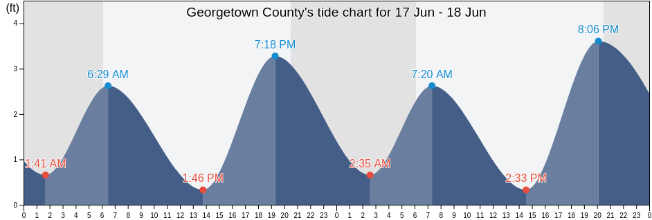
| Fri 17 | 12:32am ▼ 0.66 ft | 5:44am ▲ 2.95 ft | 1:02pm ▼ 0.66 ft | 6:29pm ▲ 2.95 ft |
▲ 6:15am | ▼ 8:12pm |
| Sat 18 | 1:28am ▼ 0.66 ft | 6:33am ▲ 2.95 ft | 1:49pm ▼ 0.33 ft | 7:16pm ▲ 3.28 ft |
▲ 6:14am | ▼ 8:13pm |
| Sun 19 | 2:21am ▼ 0.66 ft | 7:21am ▲ 2.95 ft | 2:33pm ▼ 0.33 ft | 8:01pm ▲ 3.28 ft |
▲ 6:14am | ▼ 8:14pm |
| Mon 20 | 3:09am ▼ 0.33 ft | 8:06am ▲ 2.95 ft | 3:15pm ▼ 0.33 ft | 8:43pm ▲ 3.61 ft |
▲ 6:13am | ▼ 8:14pm |
| Tue 21 | 3:56am ▼ 0.33 ft | 8:49am ▲ 2.95 ft | 3:55pm ▼ 0.33 ft | 9:23pm ▲ 3.61 ft |
▲ 6:13am | ▼ 8:15pm |
| Wed 22 | 4:40am ▼ 0.33 ft | 9:30am ▲ 2.95 ft | 4:35pm ▼ 0 ft | 10:02pm ▲ 3.61 ft |
▲ 6:12am | ▼ 8:16pm |
Best fishing times for Georgetown County today Today is an average fishing day
Major fishing times
From 12:32am to 2:32am
Opposing lunar transit (moon down)
From 1:01pm to 3:01pm
Lunar Transit (moon up)
Minor fishing times
From 2:14am to 3:14am
Moonset
From 1:31pm to 2:31pm
Moonrise
Click here to see Georgetown County fishing times for the week.
Current weather in Georgetown County
Weather
Cloud cover 13%
Temperature
73°F
Min 65°F/Max 76°F
Wind
8 mph
Wind gust 9 mph
Humidity
68%
Dew point 62°F
Click here to see Georgetown County weather for the week.
Today's weather in Georgetown County
The sun rose at 6:16am and the sunset will be at 8:11pm. There will be 13 hours and 55 minutes of sun and the average temperature is 72°F. At the moment water temperature is 68°F and the average water temperature is 68°F.
Click here to see Georgetown County weather for the week.
More tide and marine information for Georgetown County
Regions and cities in Georgetown County, South Carolina, United States
Popular locations in Georgetown County
| Murrells Inlet | Pawleys Island Pier (ocean) |