Dukes County tide charts for today, tomorrow and this week

Dukes County, Massachusetts, United States tide chart

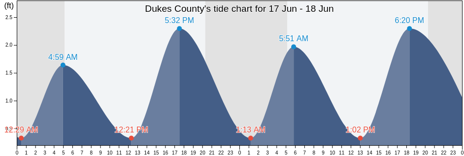
Thursday 16 May 2024, 8:00AM EDT (GMT -0400). The tide is currently falling in Dukes County. As you can see on the tide chart, the highest tide of 1.97ft will be at 3:42pm and the lowest tide of 0.33ft will be at 10:57am. Click here to see Dukes County tide chart for the week.

Next high tide

Next high tide is at
3:42pm

Next low tide

Next low tide is at
10:57am

Tide times for Dukes County

Tide table for Dukes County this week
Day Tide times for Dukes County Sunrise and sunset
1st Tide 2nd Tide 3rd Tide 4th Tide
Thu 163:06am
1.64 ft
10:57am
0.33 ft
3:42pm
1.97 ft
11:30pm
0.33 ft
5:23am 7:57pm
Fri 174:02am
1.64 ft
11:44am
0.33 ft
4:37pm
1.97 ft
5:22am 7:58pm
Sat 1812:19am
0.33 ft
4:55am
1.64 ft
12:27pm
0.33 ft
5:26pm
1.97 ft
5:21am 7:59pm
Sun 191:03am
0.33 ft
5:45am
1.97 ft
1:06pm
0.33 ft
6:12pm
2.3 ft
5:20am 8:00pm
Mon 201:45am
0.33 ft
6:32am
1.97 ft
1:43pm
0.33 ft
6:56pm
2.3 ft
5:19am 8:01pm
Tue 212:24am
0 ft
7:17am
1.97 ft
2:17pm
0.33 ft
7:39pm
2.62 ft
5:18am 8:02pm
Wed 223:02am
0 ft
8:00am
1.97 ft
2:49pm
0.33 ft
8:21pm
2.62 ft
5:18am 8:03pm

Current weather in Dukes County

Light rain shower

Weather

Light rain shower
Cloud cover 100%
Temperature

Temperature

55°F
Min 55°F/Max 56°F
Wind

Wind

29 mph
Wind gust 29 mph
Humidity

Humidity

95%
Dew point 55°F

Click here to see Dukes County weather for the week.

Today's weather in Dukes County

The sun rose at 5:23am and the sunset will be at 7:57pm. There will be 14 hours and 34 minutes of sun and the average temperature is 56°F. At the moment water temperature is 52°F and the average water temperature is 52°F.

Weather forecast for Dukes County today
0 h 3 h 6 h 9 h 12 h 15 h 18 h 21 h 24 h
Light rainLight rain showerLight rain showerLight drizzleLight rain showerLight rain showerLight rain showerLight drizzlePatchy rain nearby
56°F56°F55°F56°F56°F55°F55°F56°F56°F

Click here to see Dukes County weather for the week.

More tide and marine information for Dukes County

Regions and cities in Dukes County, Massachusetts, United States

Abels HillHedge Fence-LHommedieu Shoal betweenPenikese Island 0.8 mile northwest of
Bend-in-the-Road BeachJuniper PointQuick's Hole
Bristol BeachKatama BayQuicks Hole
Canapitsit ChannelKettle CoveQuicks Hole (middle)
Cape Poge Light 1.4 miles west ofL'Hommedieu ShoalQuicks Hole North side
Cape Poge Lt. 1.7 miles SSE ofLamberts CoveRaymond Street
Cape Poge Lt. 3.2 miles northeast ofLHommedieu Shoal north of west endRobinsons Hole 1.2 miles southeast of
Cedar Tree NeckLighthouse BeachRobinsons Hole Nashuon Point
Chappaquoit BeachLittle HarborRound Hill Point
Chappaquoit PointLobsterville BeachSouth Beach State Park
Chappaquoit Point West Falmouth HarborLong PointSouth Cape Beach
Clarks PointLucy Vincent BeachSquibnocket Beach
Cleveland LedgeMartha's Vineyard GPS BuoySquibnocket Point
CuttyhunkMarthas Vineyard GPS BuoySurf Drive Beach
Cuttyhunk Pond entranceMenauhant BeachTarpaulin Cove 1.5 miles east of
Dumpling Rocks 0.2 mile southeast ofMenemsha BeachUncatena Island (South Side)
East BeachMenemsha BightVineyard Haven
East Chop 1 mile north ofMenemsha Harbor MaVineyard Haven Harbor
East Chop-Squash MeadowMuskeget ChannelWaquoit Bay entrance
East Chop-Squash Meadow betweenMuskeget Rock 1.3 miles southwest ofWasque Point (Chappaquiddick Island)
EdgartownNo Man's LandWasque Point Chappaquiddick Island
Edgartown Great PondNobska Point 1 mile southeast ofWeepecket Island south of
Falmouth HeightsNobska Point 1.8 miles east ofWest Chop 0.2 mile west of
Falmouth Heights BeachNomans LandWest Chop 0.8 mile north of
Felix NeckNorton Point 0.5 mile north ofWest Falmouth Harbor
Fuller StreetNorton Point BeachWest Island (west side)
Gay HeadOak BluffsWest Island 1 mile Southeast of
Gay Head 1.5 miles northwest ofOceanographic InstitutionWest Tisbury
Gay Head 3 miles north ofOff Chilmark PondWoodneck Beach
Gay Head 3 miles northeast ofOff Jobs Neck PondWoods Hole
Great Rock BightOff Lake TashmooWoods Hole Oceanographic Institute
Gull I. and Nashawena I. betweenOld Silver BeachWoods Hole The Strait
Hedge Fence Lighted Gong Buoy 22Penikese Island
Hedge Fence-L'Hommedieu ShoalPenikese Island 0.2 mile south of