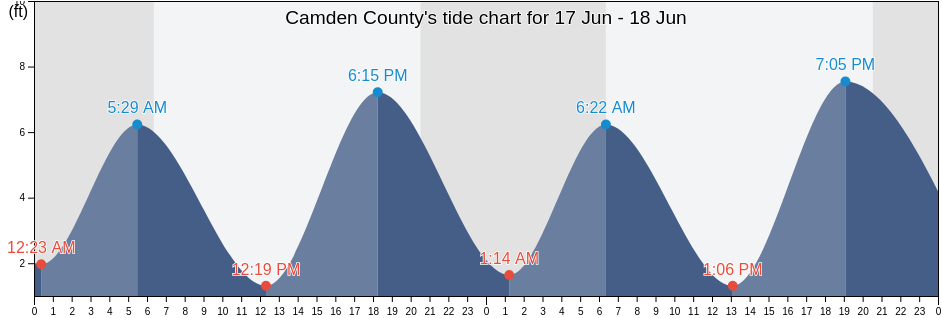
Thursday 16 May 2024, 4:45PM EDT (GMT -0400). The tide is currently falling in Camden County. As you can see on the tide chart, the highest tide of 6.56ft was at 3:46am and the lowest tide of 1.64ft was at 10:56am. Click here to see Camden County tide chart for the week.
Next high tide is at
4:39am
Next low tide is at
11:18pm
Tide times for Camden County
| Day | Tide times for Camden County |
|
||||
|---|---|---|---|---|---|---|
| 1st Tide | 2nd Tide | 3rd Tide | 4th Tide | |||
| Thu 16 | 3:46am ▲ 6.56 ft | 10:56am ▼ 1.64 ft | 4:24pm ▲ 6.23 ft | 11:18pm ▼ 1.64 ft |
▲ 6:29am | ▼ 8:15pm |
| Fri 17 | 4:39am ▲ 6.23 ft | 11:42am ▼ 1.31 ft | 5:19pm ▲ 6.56 ft | ▲ 6:29am | ▼ 8:16pm | |
| Sat 18 | 12:12am ▼ 1.64 ft | 5:31am ▲ 6.23 ft | 12:26pm ▼ 1.31 ft | 6:10pm ▲ 6.89 ft |
▲ 6:28am | ▼ 8:16pm |
| Sun 19 | 1:03am ▼ 1.64 ft | 6:20am ▲ 6.56 ft | 1:09pm ▼ 1.31 ft | 6:58pm ▲ 7.22 ft |
▲ 6:28am | ▼ 8:17pm |
| Mon 20 | 1:52am ▼ 1.31 ft | 7:07am ▲ 6.56 ft | 1:51pm ▼ 0.98 ft | 7:42pm ▲ 7.55 ft |
▲ 6:27am | ▼ 8:18pm |
| Tue 21 | 2:38am ▼ 0.98 ft | 7:53am ▲ 6.56 ft | 2:32pm ▼ 0.98 ft | 8:25pm ▲ 7.55 ft |
▲ 6:27am | ▼ 8:18pm |
| Wed 22 | 3:22am ▼ 0.98 ft | 8:37am ▲ 6.56 ft | 3:12pm ▼ 0.66 ft | 9:07pm ▲ 7.87 ft |
▲ 6:26am | ▼ 8:19pm |
Best fishing times for Camden County today Today is an average fishing day
Major fishing times
From 12:45am to 2:45am
Opposing lunar transit (moon down)
From 1:13pm to 3:13pm
Lunar Transit (moon up)
Minor fishing times
From 2:20am to 3:20am
Moonset
From 1:43pm to 2:43pm
Moonrise
Current weather in Camden County
Weather
Cloud cover 14%
Temperature
80°F
Min 69°F/Max 81°F
Wind
4 mph
Wind gust 7 mph
Humidity
49%
Dew point 60°F
Click here to see Camden County weather for the week.
Today's weather in Camden County
The sun rose at 6:29am and the sunset will be at 8:15pm. There will be 13 hours and 46 minutes of sun and the average temperature is 77°F. At the moment water temperature is 73°F and the average water temperature is 73°F.
Click here to see Camden County weather for the week.
