Cape May County tide charts for today, tomorrow and this week

Cape May County, New Jersey, United States tide chart

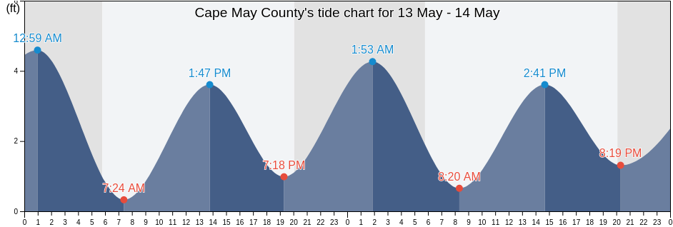
Tuesday 23 April 2024, 10:13PM EDT (GMT -0400). The tide is currently falling in Cape May County. As you can see on the tide chart, the highest tide of 4.92ft was at 9:18pm and the lowest tide of 0ft was at 2:55am. Click here to see Cape May County tide chart for the week.

Next high tide

Next high tide is at
9:34am

Next low tide

Next low tide is at
3:35am

Tide times for Cape May County

Tide table for Cape May County this week
Day Tide times for Cape May County Sunrise and sunset
1st Tide 2nd Tide 3rd Tide 4th Tide
Tue 232:55am
0 ft
8:59am
4.27 ft
3:01pm
0.33 ft
9:18pm
4.92 ft
6:10am 7:45pm
Wed 243:35am
0 ft
9:34am
3.94 ft
3:37pm
0.33 ft
9:49pm
4.92 ft
6:09am 7:46pm
Thu 254:14am
0 ft
10:09am
3.94 ft
4:11pm
0.33 ft
10:21pm
4.59 ft
6:08am 7:47pm
Fri 264:52am
0 ft
10:45am
3.94 ft
4:44pm
0.33 ft
10:54pm
4.59 ft
6:06am 7:48pm
Sat 275:31am
0.33 ft
11:26am
3.61 ft
5:18pm
0.66 ft
11:35pm
4.59 ft
6:05am 7:49pm
Sun 286:11am
0.33 ft
12:14pm
3.61 ft
5:57pm
0.66 ft
6:04am 7:50pm
Mon 2912:25am
4.59 ft
6:58am
0.33 ft
1:10pm
3.61 ft
6:45pm
0.98 ft
6:03am 7:51pm

Best fishing times for Cape May County today Today is an excellent fishing day

Major fishing times

From 6:44pm to 8:44pm

Lunar Transit (moon up)

Minor fishing times

From 5:22am to 6:22am

Moonset

From 7:14pm to 8:14pm

Moonrise

Click here to see Cape May County fishing times for the week.

Current weather in Cape May County

Partly cloudy

Weather

Cloud cover 46%
Temperature

Temperature

51°F
Min 47°F/Max 52°F
Wind

Wind

18 mph
Wind gust 19 mph
Humidity

Humidity

76%
Dew point 44°F

Click here to see Cape May County weather for the week.

Today's weather in Cape May County

The sun rose at 6:10am and the sun went down at 7:45pm. Today there was 13 hours and 35 minutes of sun and the average temperature is 50°F. At the moment water temperature is 49°F and the average water temperature is 49°F.

Weather forecast for Cape May County today
0 h 3 h 6 h 9 h 12 h 15 h 18 h 21 h 24 h
Partly cloudyPartly cloudyPartly cloudyPartly cloudyPartly cloudyPartly cloudyPartly cloudyPartly cloudyPartly cloudy
48°F52°F47°F52°F51°F51°F47°F51°F52°F

Click here to see Cape May County weather for the week.

More tide and marine information for Cape May County

Regions and cities in Cape May County, New Jersey, United States

2nd BeachCorson's Inlet EntranceOld Turtle Thorofare
AvalonCorsons Inlet EntranceOld Turtle Thorofare RR bridge
Bay Shore Channel (city of Town Bank)Corsons Inlet State Park (Strathmere)Rio Grande
Bay Shore Channel (north)Delaware Bay EntranceSea Isle City
Beesleys PointDennis Creek (2.5 NM Above Entrance)Sluice Creek (Route 47 Bridge Dennis Creek)
Bidwell Creek (Route 47 Bridge)Dennis Creek (Route 47 Bridge)Sluice Creek Route 47 Bridge Dennis Creek
Bidwell Creek EntranceDennis Creek 2.5 N.Mi. Above EntranceStites Sound
Bidwell Creek Route 47 BridgeDennis Creek Route 47 BridgeStockton Avenue
Brandywine Shoal LightDias CreekStone Harbor (Great Channel)
Brandywine Shoal Light 0.5nm west ofDias Creek Route 47 BridgeStone Harbor Great Channel
Brandywine Shoal Light BayEast Creek (Route 47 Bridge)Strathmere (Strathmere Bay)
Cape Henlopen 2 miles northeast ofEast Creek Route 47 BridgeStrathmere Strathmere Bay
Cape Henlopen 4.8 n.mi. northeast ofErmaSwain Channel (Taylor Sound)
Cape Henlopen 5 miles north ofFive Fathom Bank Traffic LaneSwain Channel Taylor Sound
Cape Island CreekGreat Sound west sideTownsend Sound
Cape Island Creek (Cape May)Hereford InletTownsends Inlet
Cape Island Creek Cape MayHerring PointTuckahoe (Tuckahoe River)
Cape MayHigbee BeachTuckahoe Tuckahoe River
Cape May (Atlantic Ocean)Ingram ThorofareUpper Township (Petersburg)
Cape May Atlantic OceanJenkins SoundVillas
Cape May Canal east endLong Reach (Ingram Thorofare)Villas (Lower Township)
Cape May Canal west endLong Reach Ingram ThorofareWest Cape May
Cape May ChannelLudlam Bay (West Side)West Creek (0.7 NM Above Entrance)
Cape May Court HouseLudlam Bay West SideWest Creek 0.7 N.Mi. Above Entrance
Cape May ferry terminalMcCrie ShoalWest Wildwood (Grassy Sound)
Cape May HarborMiddle ThorofareWest Wildwood Grassy Sound
Cape May Harbor entranceMiddle Thorofare Ocean Drive BridgeWhitesboro-Burleigh
Cape May Point (Sunset Beach)New JettyWildwood
Cape May Point 1.4 n.mi. SSW ofNorth Cape MayWildwood Crest
Cape May Point 2.7 n.mi. SSW ofNorth Highlands BeachWildwood Crest (Ocean Pier)
Cape May Point Sunset BeachNorth WildwoodWildwood Crest Ocean Pier
Cedar Swamp Creek (Tuckahoe River)Nummy Island (Grassy Sound Channel)Wildwood Crest Sunset Lake
Cedar Swamp Creek Tuckahoe RiverNummy Island Grassy Sound ChannelWoodbine
Cooks BeachOcean City
Corson InletOcean Drive Bridge